
Canada’s Top Ten Weather Stories 2017
– By David Phillips, Environment and Climate Change Canada –
Our climate is changing, and it’s happening here and now
Worldwide changes in extreme precipitation and temperature are consistent with what we anticipate from global warming. Science is linking climate change with increased risk of forest fires, floods, heavy rains, and the most powerful hurricanes. Canadians experienced many of these extremes in 2017.
Canadians had plenty to “weather” in 2017. Property damage from weather extremes cost Canadian insurers and governments millions of dollars. Between the few floods, the many wildfires and record dry temperatures, 2017 was a year of too much— too dry, too hot, too fiery, too wet, too cool, but not too cold. It was the eighth warmest period in 70 years of reporting weather, with temperatures averaging 1.4°C above normal. This year also marked the 21st consecutive year warmer than normal, matching the trend for the rest of the world.
From a list of 100 significant weather events that occurred across Canada in 2017, we picked the top ten weather stories that were the most significant. These stories were selected based on the degree of impact on Canadians, the size of area affected, the economic and environmental effects and how long it remained a top news story in Canadian media. As the Top Ten Weather Stories of 2017 confirm, our communities must become more resilient – not only for what lies ahead, but for the changing climate that is already on our doorstep.
Top Ten number 1: British Columbia’s longest and most destructive wildfire season
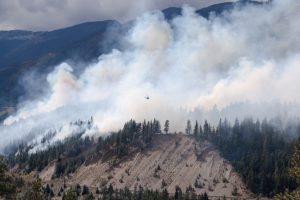
In 2017, across the southern British Columbia (BC) interior, an extraordinary weather change occurred – the region’s wettest spring was followed by its driest summer ever. The result was the longest, most disastrous wildfire season in the province’s history. A province-wide state of emergency, the first in 15 years and the province’s longest one, began on July 7 and lasted until September 15. Aggressive wildfires forced 50,000 British Columbians to leave their homes.
A growing snowpack and heavy rains in May kept BC wildfire staff busier helping with flood relief than firefighting. But excessive spring rains mixed with mild temperatures helped vegetation growth that quickly turned into kindling when a hot and dry start to summer didn’t let up. Occasionally, low pressure systems brought gusty, erratic winds, dry lightning and low humidity but no long, sustained soaking rains to quell the inevitable flames.
One of the earliest and largest fires burned west of Kamloops in the Ashcroft-Cache Creek-Clinton area. In the Interior, Ashcroft recorded only a thimble-full of rain over 13 weeks, while Kamloops and Kelowna had even less. In the end, fires burned over 300 structures as well as hundreds of power poles and transmission towers. Ranchers in cattle country returned to scorched fields, dead livestock and burned fences.
In total, the BC Wildfire Service reported 1,265 fires that scorched 1.2 million hectares of timber, bush and grassland (an area twice the size of Prince Edward Island), smashing the previous record for burned land by 30%. Total firefighting costs exceeded half a billion dollars and insured property losses reached close to $130 million.
Top Ten number 2: Dry and hot in the West

A massive dome of heat set the stage for record-breaking summer temperatures across the Canadian West. As a result, southern regions between the British Columbia (BC) Interior and the southeastern Prairies faced their driest summer in 70 years, with many areas recording less than half their normal rainfall during the growing season.
In Calgary, the average temperature between May and August was 16.4°C, making it the warmest May to August since 1881. Other hot spots included Medicine Hat, with 34 days without rain in July and August hotter than 30°C, as well as Kamloops with 42 days without rain.
Across the West no other summer as far back as 1948, had been so dry. The record dryness was centered on Regina and Moose Jaw and between Kamloops and Kelowna. Total rainfall in Regina from April to October was 119.3 mm compared to the previous record of 151.5 mm in 1961. In Kelowna, it was not only the warmest August on record, it was also the driest. Just two-tenths of a millimeter of rain fell in the city compared to the 32.1 mm it usually receives in August; in July there was no rain at all. Attendance at outdoor attractions dropped, golf courses struggled to keep their greens green, low river flows and heated water harmed fish, and rising temperatures pushed summer electricity use to all-time highs. Hot days were also dry ones.
Credit must be paid to growers of any product that made it to market, with the heat and drought impacting crops across the board. Livestock also suffered, as watering holes and grazing land dried up, with hundreds of cattle dying from dehydration. The only positive outcome from the persistent dry heat was a reduction in mosquitoes.
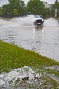
Top Ten number 3: Spring flooding in Quebec and Ontario
At the beginning of May, flood forecasters across Quebec and eastern Ontario were concerned. In the previous month, several major, slow-moving weather systems had soaked the region with record rains. Over half the snow pack, loaded with water, still needed to melt, and the 7-day forecast called for more showers falling on the partly frozen ground. Instantly, bloated rivers and streams overflowed, and sewers backed up. Several rivers exceeded the maximum amount water released in the past and overflowed from Gananoque to Gaspésie.
The Quebec government claimed the spring downpour was the worst ever recorded in the province over the past 55 years. In Montréal, April rains totaled 156.2 mm − the second wettest in 147 years. Both Ottawa and Montréal had their wettest spring in history – 400 mm or more with records dating back to the 1870s. Spring flooding occurred in hundreds of communities, forcing 4,000 people to leave their homes. Dozens of towns and cities declared states of emergency, including Gatineau, Laval and Montréal. Up to 2,300 Canadian military personnel were brought in to assist with flood preparations and rescue relief.
According to the Insurance Bureau of Canada, spring flooding in April and May resulted in 15,750 claims and $223 million in property damages. In total, more than 5,000 residences were flooded, 550 roads were washed or swept away from floods or landslides, and – tragically – on May 6, two people were swept away by the swollen Sainte-Anne River in the Gaspé region.
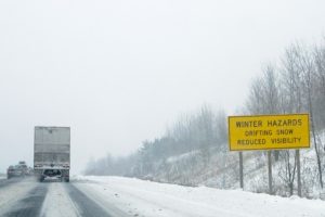
Top Ten number 4: British Columbia’s cold and snowy winter
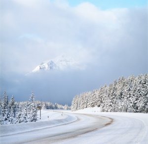
Winter was mild across Canada − the seventh warmest in 70 years – with only British Columbia (BC) experiencing colder-than-normal temperatures. Meanwhile, residents west of the Rockies struggled to cope with their second coldest winter in 25 years.
In early January, winter across much of BC went from mild to wild and stayed that way until two weeks before spring. What made the winter memorable was not the amount of snow but the duration, frequency and length of snowfall, as well as the amount of snow on the ground. In addition, there were several days with sub-freezing temperatures – more than any other winter in 25 years.
Too much winter for too long had enormous impacts on the Lower Mainland and parts of Vancouver Island. Community centres became warming centres. Retailers couldn’t keep up with the demand for snow tires, snow shovels and road salt. Ski conditions were fantastic but getting to mountain resorts was, at times, an issue. On roads and walkways, frequent bouts of freeze and thaw made for especially icy, slippery surfaces with numerous potholes.
The long winter kept landscapers and gardeners a month behind schedule, and at times heavy, sticky snow crushed blossoms and dropped bushes.
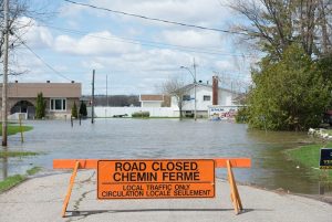
Top Ten number 5: Another Windsor flood: two storms of the century in a year
Less than a year after a record $153 million flood hit Windsor and Essex County, another downpour with equally heavy rains and damage flooded the same area.
Light rain began falling before noon on August 28. It continued with heavier amounts in the early evening. Storms kept happening overnight. The next day intense thunderstorms re-occurred and remained stationary. In less than 48 hours, 222 mm of rain fell in southwest Windsor and 140 to 200 mm in Riverside-Tecumseh.
However, it was the nearby community of LaSalle that was hit the hardest with 125 mm of rain on August 28. Another 160 mm fell the next day. In total an incredible 285 mm fell in 32 hours. This was one of the wettest moments in Eastern Canadian history. Flood waters filled thousands of basements to the rafters and stalled vehicles on waist-high flooded streets. The scene was a repeat of September 2016, when curbs were piled high with soaked carpets, rotten furniture, broken appliances and drenched personal belongings.
Insurance payouts totaled $154 million – the most expensive single-storm loss across Canada in 2017.
Top Ten number 6: Central Canada’s missing summer

Ontario and Quebec residents knew it was going to be hard to beat last summer’s hot days, record-warm lake water and a season-long stretch of delightful vacation weather. But no one could have predicted what a bummer of a summer 2017 would turn out to be. Total rainfall from April to July was well above normal in most places, including the Great Lakes and St. Lawrence River Basin, where it was the wettest in 70 years of observations. Cool, overcast weather and frequent spring showers continued throughout the summer.
The seasons changed but not the jet stream, stubbornly hanging out south of the Great Lakes for weeks on end. As a result, mid-latitude weather systems continually crossed the region two to three times a week. Every day had a constant and frustrating suite of cool air, endless hours of rain, and an absence of sunshine and continued warmth. Any small break in the cloud cover or occasional warm day raised false hopes that summer had finally arrived.
Farmers who had faced dryness in 2016 were now cursing 2017’s super saturation that left them once again fearing the loss of their crops. By mid-June corn should have sprouted, the first hay should have been cut and baled, and soybeans should have been planted, but agricultural activities remained weeks behind until September. Even the poor bees, who should have been busy pollinating, were kept hive-bound by the cool, wet weather.
Rain, rain, and more rain filled up every nook and cranny, including waterways like Lake Ontario that reached a record 75.9 metres above sea level in May – the highest it has been since at least 1918. Its rising waters blocked access to the Toronto Islands from mid-May to the end of July, keeping the popular summer destination off limits for both city residents and tourists.
Top Ten number 7: A new storm of the century
The winter’s worst storm stretched across Eastern Canada striking parts of Ontario on March 13, before moving towards the East into Quebec and Atlantic Canada over the next two days.
The storm led to a multi-car pile-up in whiteout conditions in Brockville that involved 15 transport trucks and other vehicles on Highway 401. Officials closed the highway in both directions as twisted metal covered the road and a highly toxic acid spill polluted the air. The storm then moved into Quebec, where it dumped 50 cm of snow at over half the weather reporting stations across the south. No previous storm had beaten so many snowfall records in Quebec, with some stations reporting more than a metre of snow. In Gaspésie, winds reaching 175 km/h caused total whiteouts. In addition, a storm powered by 100 km/h winds along the St. Lawrence River had tragic consequences. The monster storm took five lives and left hundreds of people stranded in a multitude of accidents across the south. On one stretch of highway in Montréal, 300 people spent the night stranded in their cars.
Moving further east on the Ides of March, the storm still packed enough punch to cripple parts of Atlantic Canada.
Top Ten number 8: Summer in September
Fall officially arrived on September 22 at 16:02 EDT.
The next day marked the beginning of the warmest period in 2017 across Eastern Canada. From September 22 to 27, over a thousand heat records fell as humidex values shot up close to or above 40, prompting a week-long stretch of heat warnings.
In the lead up to the five-day scorcher, there were two weeks of delightfully sunny, warm and rain-free weather. It was the most beautiful stretch of summer weather in the entire year. The welcomed warmth went into October with southern Quebec experiencing its warmest month since at least 1870. The unusual heat across the eastern half of North America was due to a strong ridge of high pressure south of the Great Lakes that caused a large northward bulge in the jet stream.
It’s likely that the four major hurricanes – Harvey, Irma, Jose and Maria – that happened earlier in the season shook up the atmosphere, enabling summer temperatures to arrive eventually, even though it was after the autumnal equinox.
Dozens of cities across eastern Canada had their warmest September and October on record. For some places, September 25 was the hottest day of the year and the hottest fall day on record, with peaks between 30° and 35°C. Everywhere you looked there were full patios, people strolling in the sun and crowded beaches without lifeguards. The abundant dry-warm days were a blessing for farmers harvesting crops and vintners picking grapes. In Annapolis Valley, apple growers had to turn on overhead sprinklers.
To everyone’s dismay, the fall heat wave finally came to an end on September 27 when a cold front swept across the south and brought a much cooler air mass to the region.
Top Ten number 9: Newfoundland’s Brier blast
The traditional winter months of November through February were not too demanding across Newfoundland and Labrador. However, when a series of powerful and impactful winter storms hit the province in March and early April, the “soft winter” turned hard. Slow-moving blizzards racked the province with some of the toughest weather in years, featuring shrieking gales, humongous snows and freezing rain. Hurricane-force winds ravaged Newfoundland on March 1 and 2, but it was the “Brier blast” on March 11 that defined the rest of winter and spring.
On the last Saturday of the Canadian curling championship, curlers, spectators and locals in St. John’s faced the usual Newfoundland mix of rain, freezing rain and snow in near-zero visibility. However, it was the winds that stirred the snowstorm into one of the fiercest storms the province had seen in more than a decade. Wind gusts in the Avalon Peninsula peaked at a hurricane-force of 190 km/h at Bay de Verde, leaving over 70,000 residents and visitors in the dark. It was said that wind speed and storm damages exceeded those from Hurricane Igor in 2010. Winds pulled trees out of the ground, brought down traffic lights and power lines, blew away entire roofs and overturned vehicles. In some cases, strong winds ripped the second story floor off houses.
In total, the brutal storm cost almost $60 million in insurance losses from 4,500 claims.
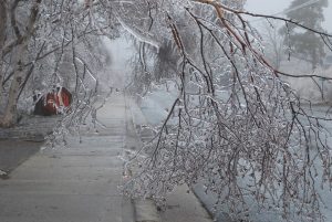
Top Ten number 10: New Brunswick’s glaze storm
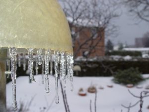
A long-lasting mix of rain, snow, freezing rain and ice pellets dangerously impacted portions of Quebec and Atlantic Canada during the last week of January. This led to the deaths of two people, dozens of injuries, and more than 30 individuals being sick from carbon monoxide poisoning.
At the peak of this event, power lines that were stressed by wind and heavily coated in ice, snapped. This left close to 300,000 residents in the dark and cold. About one in three New Brunswick residents had their lives turned upside down. Power remained off in some communities for up to 12 days as entire hydro grids were rebuilt. Northern Acadian communities were especially hard hit. Schools were closed for up to four days and public transit was shut down. Canadian Armed Forces were deployed to help with the ongoing emergency response. According to New Brunswick Power, the province endured four major storms in the last two years compared to only two extreme storms in the previous twenty years. Storm surges came ashore in Quebec and there was local flooding in the Gaspé region. In Halifax, strong winds from the East, gusting close to 100 km/h scattered construction debris and tore down power lines.
Regional weather highlights
Atlantic Canada
Two January nor’easters cripple Newfoundland
Four February storms in 10 days
Gander disappears under snow
New Brunswick spring flooding
Record wet May in Cape Breton Island
Rock-tossing storms in Acadia
Big year for icebergs
Hurricane Gert − no Harvey, Irma or Maria
Labrador’s miserable summer weather
October blows across the East
Quebec
Preference for snow not freezing rain
Quebec’s new single-day snowfall record in Gaspésie
Open and soft winter
Maple sap runs early
Father’s Day tornadoes
Major hailers in July
Beauce tornado in August
Quebec’s major microburst
Quebec’s summer of contrasts
Suspicious-looking tornado in October
Pre-Halloween weather bomb
Ontario
Year of the pothole
Ontario-wide SAD
January-thaw through February
Short skating season on the Rideau Canal
Ottawa – truly the world’s snowiest nation’s capital
Major property losses from strong March winds
June thunder flood
Canada 150 celebration soaker
Huntsville tornadoes
Leamington and Hawkesville tornadoes
Microburst ends September heat wave
Hurricane Nate arrives for Thanksgiving
Tropical storm Philippe and more Ottawa rains
Ottawa’s year-long big wet
Prairie Provinces
Mackenzie clipper brings cold to the Prairies
Bonspiel January thaw
Alberta’s metre-sized snowfall
Nature warms hearts on Valentine’s
March storm buries Churchill
Red River non-flood
Still harvesting last year’s crop
Big May blow across the West
Summer of Saskatoon hailers
Hailers and plough winds in Red Deer
Calgary Stampede – hot and dry except for one day
Early July supercells in Saskatchewan
“Pudding-cup” hail and floods across central Alberta
Costly July storms in Alberta Foothills
Manitoba forest fire season more active than usual
Winnipeg … the best weather this summer?
Forest fires in Alberta
Powerful winds too strong for trains
British Columbia
Year of avalanches
Damaging April wind storm
Wet and gloomy weather delays spring planting
Okanagan spring flooding
Trio of October windstorms
Snow-vember in Vancouver/Victoria
The North
Northern ice roads later and later
Early winter low snowfall in Northwest Territories
Arctic heat wave
Arctic sea ice going, going…
Fierce September gales
Weather delays Halloween
Warm November gales
David Phillips, Insurance Losses, Record temperatures, top ten weather stories, Weather Extremes