
Canada’s top 10 weather stories of 2021
– By David Phillips –
This article was originally published by Environment and Climate Change Canada.
Introduction
Not in 26 years of releasing the Top 10 Weather Events has there been anything comparable to this year, where Canadians endured such a stream of weather extremes. The year began with windstorms causing multi-million dollar damage across the West in early January and ended with rain, windstorms and floods causing multi-billion dollars of damage in British Columbia. Although we cannot attribute a single weather event to human-caused climate change, the evidence is conclusive — we are experiencing more intense and more frequent extreme weather. Climate change is leading to more frequent and more intense disasters around the world. This was the year southern Canadians began seeing this firsthand. There were no new types of weather this year – our grandparents coped with the same rain, heat, floods, fires and drought. But the extremes were of a different nature than in the past. They were more widespread, intense, frequent and impactful.
Canada continued to warm in 2021 for the 26th consecutive year and was one of the warmest in 75 years. Canada’s excessive heat in early summer helped to make July the planet’s warmest month in more than a century and a half. No place in the world has warmed more than Canada’s North. Three decades of gradual but relentless warming have dramatically changed the geography in the North: fragile ice shelves are crumbling into the ocean, sea ice is thinning and shrinking, sea levels are rising slowly and ocean waters are becoming less salty, more acidic and warmer throughout.
In 2021, Canadians witnessed the real threat and impact of climate change all around them and were shocked by the variety and frequency of weather extremes. British Columbia became ground zero for weather catastrophes. The province was dried out, scorched, flooded and inundated with mud, rock and debris flows. Owing to the extraordinary early summer heat and drought, British Columbia suffered a tragic week of weather and from unbelievable fall-season rains and floods, likely the most destructive and expensive year to date.
The Prairies continued to be hot and dry as they have been for the past 2 or 3 years, with economic costs in the billions of dollars. The wildfire season started early, burned later, and became bigger and hotter, igniting a near-record area of forests across Canada. The smoke affected millions of Canadians for days and months. For instance, this year Calgary saw 512 hours of smoke and haze, far exceeding the average of 12 hours per year.
The unseasonably warm Atlantic Ocean waters led to another very active tropical storm season. Canada was touched by 6 tropical storms, including Hurricane Larry in Newfoundland and Labrador, the longest-lasting Category 5 hurricane in Atlantic basin history.
The year showed that heat can be a disaster and even more catastrophic than ever before thought possible. Temperature extremes in Canada covered a range of 100 degrees, varying from a record hot of 49.6 °C, causing nearly 800 fatalities in British Columbia and Alberta, to the coldest temperature in 4 years at -51.9 °C. Much of western and central Canada faced some of the coldest temperatures in years in mid-February when the dreaded Arctic blast impacted the entire country. In 2021, Calgary reinforced its reputation as the hailstorm capital when a half-billion-dollar hailer struck the city for a few minutes on July 2.
Volatile weather also occurred when a rare tornado, the first one in 45 years, touched down in Vancouver. In addition, the usual hot spot for tornadoes in Canada, the central Prairies, had a 2 month period in mid-summer without a single tornado. Yet Canada, overall, has never seen so many major EF2 tornadoes with winds exceeding 175 km/h, as in this year.
At times in 2021, Canada even broke records for the number of records broken. Property damage from weather cost Canadians millions of dollars and the economy billions. Based on preliminary estimates compiled by Catastrophe Indices and Quantification Inc. (CatIQ), there were 13 major catastrophic weather events with billions of dollars in insured losses. It will be months before final figures are tallied. In the end, insured damages will only be a fraction of the total economic costs and together with business losses and infrastructure costs for repairing and rebuilding, 2021 will undoubtedly be the most expensive in history.
From a list of at least 100 significant weather happenings across Canada in 2021, events were ranked from 1 to 10 based on factors that included the degree to which Canada and Canadians were impacted, the extent of the area affected, economic and environmental effects and the event’s longevity as a top news story. Incredibly, British Columbia’s terrible weather led the way in the first 5 of the Top 10 Weather Events in 2021.
Top 10 Weather Events in 2021
1. Record heat under the dome
A few days into summer, Canada, the second coldest country in the world, experienced a Death Valley moment with temperatures approaching 50 °C. Lytton, a village 260 km northeast of Vancouver in British Columbia’s Fraser Canyon, set a new Canadian record high temperature of 49.6 °C on June 29, nearly 24 °C higher than normal. Two days earlier, on June 27, Lytton broke the previous national record (45 °C) that had stood for 84 years from Yellowgrass and Midale, Saskatchewan, and exceeded that record on June 28 and yet again on June 29. The next day, Canadians were shocked to see that 90% of the small town of Lytton had burned to the ground. The raging wildfire resulted in 2 deaths and displaced 1200. Lytton experienced a temperature hotter than any in the United States outside the Desert Southwest, and hotter than any temperature ever observed in Europe or South America. Indeed, it was the most extreme high temperature observed anywhere in the world above 45° latitude. Also remarkable, it was not just Lytton that broke the previous Canadian heat record, as 6 other locations exceeded the previous high recorded in 1937, including the cities of Kamloops and Kelowna.
In the final 10 days of June, a sprawling high-pressure ridge, an atmospheric juggernaut with incredible strength, height, scope and persistence, parked itself over western North America. Under this heat dome, the air was compressed enough to cook the atmosphere and dissipate clouds. Hot temperatures were made even hotter by the drought-stricken landscape. With so little moisture in the air and land, solar energy that might otherwise have gone into evaporating water, thus cooling, instead made hot air even hotter. The timing was also crucial. On June 21, the solar altitude is the highest and the day length is the longest of the year. The hot spell was particularly significant as it occurred early before people had a chance to acclimatize to summer weather.
The fact that the widespread heatwave happened so early in the season and lasted nearly 2 weeks was unprecedented and it affected millions of Canadians from the Canadian-American boundary north to the Arctic Circle. Daytime highs were 15 °C to 25 °C above normal with little reprieve at night as the mercury could not fall much below 20 °C. The dome would not budge and only expanded eastward. From June 24 to July 4, the inferno-like heat blew past 1000 daily temperature records over 11 days, with over 100 records between 40 °C and 50 °C and some by 12 degrees, not decimals. One eminent American climatologist claimed no other heatwave in the world had ever broken more temperature records than the Canadian heatwave.
The blistering heat also occurred along the Pacific Coast, and on June 28, Victoria recorded an unfathomable extreme near 40 °C, an all-time record a staggering 20 °C above average. This beat the previous all-time record by a significant 3 degrees! Kamloops had 6 days of greater than 40 °C temperatures in June, significant because the city had never seen 40 °C in June before. In addition to the extreme heat, some cities in the west were under a special air quality advisory. In Alberta, Edmonton matched its record of 7 consecutive days with highs above 30 °C. Calgary broke 5 records in a row, including new June 29 and July 1 records of 36.3 °C and nearly broke the all-time highest temperature record for the city over the past 140 years of 36.6 °C, which was set in 2019. Among the thousands of temperature records broken across the Northwest was on June 30, when Fort Smith, Northwest Territories reached 39.9 °C, the highest temperature ever recorded north of latitude 60°.
This unbearable heat left millions overheated in western Canada. Power grids failed, asphalt melted, highways buckled, and fruit baked on vines and trees. City workers turned on portable spray parks, added heavy misters, converted hockey rinks into cooling centres, and opened libraries and recreation centres around the clock. Hospitals cancelled outdoor COVID-19 vaccination clinics or moved them indoors. Because it was almost impossible to go outside, people moved mattresses into basements to wait it out. Many local residents checked into air-conditioned hotels with their cats and dogs to escape the heat. Restaurants and bars closed after kitchen temperatures rose to potentially deadly levels. Some companies cut operating hours or suspended business, and outdoor workers opted to start before dawn and finish work at noon.
The hottest week in Canadian history was also one of the most harmful. In Vancouver alone, the historic heatwave was a contributing factor in the premature deaths of almost 600 people with more than half occurring over just 2 days. Alberta reported 185 heat-related fatalities. Two-thirds of the heatstroke victims were age 60 or older with underlying health conditions, socially isolated or living alone in their homes. More than 650 000 farm animals perished in the extreme heat. Poultry producers desperately sprayed barn walls with water to prevent birds from dying. Dairy cows gave less milk and raspberry growers watched as their crops withered on the stems. Countless wild animals and birds also perished in the record heat. Unfortunately, the late June heat dome coincided with the lowest tides in years and some of the longest days. As a result, along the Pacific coast, an estimated billion intertidal and marine organisms died, including mussels, clams and fish, leaving shorelines with a foul odour for days.
2. British Columbia’s flood of floods
On November 13, on the same day when almost 200 countries agreed to the Glasgow Climate Pact at COP-26 with the aim of beginning to lessen the threat and impact of climate-triggered extremes, a mammoth storm began its descent on the south coast of British Columbia. For just over 2 days, massive amounts of rain, powered by jet stream winds, swamped a widespread and already soggy south coast and interior of British Columbia. The sum of 7 atmospheric rivers and 3 weather bombs in November created a flood of floods, quite likely the most destructive and expensive weather disaster in Canadian history.
Note:
While it is a well-known concept for meteorologists, 2021 was the year that the term atmospheric river became familiar in the national mainstream.
These “rivers in the sky”, also called “pineapple express” or “tropical punch” storms, are long, narrow conveyors of dense moisture from the tropics that cruise more than 3 kilometres above the ocean. The precipitation load is often 10 to 15 times the average discharge of major rivers like the Mississippi or St. Lawrence, or twice the discharge of the Amazon, the world’s largest river. Often lasting less than 24 hours, they act like giant firehoses aimed at landmasses, where they confront topography and suddenly drop their cargo. These excessive rains and melting snows in high terrain, often lead to flash floods, mudslides, landslides and debris flows.
In September, after an extraordinarily warm and dry spring and summer across British Columbia, concerns abruptly switched from drought to floods and from wildfires to winds. In an early start to a record wet fall season, several storms continued to soak and buffet the south coast of British Columbia for the next 3 months. Across the southwestern region, September and October were hugely wet with twice the normal precipitation. November was even wetter and windier when a historic 7 atmospheric river-fuelled storm drenched the south coast with historic amounts of warm rain, highlighted mid-month by a weekend superstorm. This large, wet system also featured unseasonably warm temperatures around 15 °C, enough to melt earlier snows at mid-elevations. The storm river arrived on November 13 penetrating right past the southern tip of Vancouver Island before releasing buckets of rain as it locked into place much deeper inland up the Fraser Valley. Further, it was not the usual 24-hour atmospheric river event, but a persistent 2.5-day episode having more time to unleash its load on the south as well. Nearly a typically month’s worth of rain poured into the region that weekend, combining with additional snowmelt in the Coast Mountains, to overwhelm watercourses of all sizes. The saturated ground just could not absorb any more water and runoff was immediate. Like so many weather disasters, it was not the single day’s weather or the one storm, but cumulative effects often beginning weeks or months before.
Rainfall totals associated with the mid-November atmospheric river were astronomical. Some places received between 200 and 300 mm in 2.5 days; well above November’s average monthly total. In 2 days, 40 daily rainfall records were eclipsed with totals experienced only once every 100 years. In many places in the southwest it rained every day during the first half of November, so when the pace picked up on November 13, it did not seem so strange, nor did early reports of stranded motorists. Even the usual rain-shadow along the eastern side of Vancouver Island was drenched by record-breaking rainfalls over 3 days, causing highway washouts and local flooding. At the same time, winds gusted up to 90 km/h, so strong, that buildings shook. At times during the week, there were power outages affecting several thousand power users.
With water flowing everywhere, the sides of mountains broke away, unleashing an avalanche of debris. Waters and mud rolled over all major highways in both directions, took out bridges, and trapped drivers and passengers. Walls of debris broadsided vehicles sending them rolling over and off highways. The rain-flood storm led to the tragic loss of at least 6 lives and close to 15 000 evacuations. Search and rescue teams dug deep into the mud looking for cars and missing passengers. Parts of the Trans-Canada Highway were no longer drivable. British Columbia Highway 8 essentially fell into the Nicola River, and sections of the Coquihalla Highway – the major route connecting Vancouver to the British Columbia Interior and the rest of Canada – closed until 2022. Flooding submerged entire towns and parts of cities. Merritt’s 7000 residents were evacuated for the second time this year when rising waters disabled the wastewater treatment plant. Dykes were breached, leaving sections of downtown Princeton underwater. Rural communities and First Nations communities became isolated when swollen rivers washed away the only roads into town and all connecting bridges. Several communities came under a state of local emergency, and everyone was in a province-wide emergency for at least 2 weeks – the third this year. The largest port in Canada was closed in Vancouver, worsening the already taxed supply chain situation across the country. Cell and internet services were interrupted by multiple severed fibres, making rescue efforts challenging. Valuable farm fields turned into wetlands. Approximately 1.3 million animals died in flooded fields, isolated by floods in a real agricultural disaster.
Canadian military personnel quickly moved in to help with rescues, recovery and restoration. They airlifted food and feed to various communities and large farms isolated by rising waters and shuttered roads. In the midst of the misery, there were many heroes as first responders, search and rescue teams, and thousands of ordinary citizens risked everything to recover, respond to, and shelter thousands put into perilous conditions. Thousands of workers and volunteers toiled tirelessly to restore a sense of normalcy in short order, though it may be well into 2022 before damaged infrastructure is restored.
Insurance cost-losses combined with non-insured private property losses are expected to be in the billions of dollars, once calculated in 2022. Uninsured losses to infrastructure (restoring and rebuilding bridges, roads and railways) may tally to multiple billions, likely making BC’s flood of floods the most expensive weather event in Canadian history. In the same year that the province experienced the most tragic weather disaster in Canada, it was now also suffering the most expensive and most destructive natural disaster.
And the rains kept coming! British Columbia braced for more rain and flood impacts. Three more atmospheric rivers took aim at the south coast beginning November 24 through to the end of the month. While these storms were less intense and faster moving than the big one, additional rains in close succession exacerbated the vulnerabilities with cascading impacts. In the last week of November, rainfall totals in the south coast ranged from 100 mm at Vancouver to 350 mm at Hope. By the end of November, fall season 2021 was officially the wettest on record for at least 10 sites across the south coast of BC, and yet the wet season was, climatologically speaking, only 40% complete.
3. Canada dry coast to coast
Veteran farmers and ranchers do not hesitate to call this year’s drought across Western Canada one of the worst in history. Farmers compare it to 1988 and 1961; historians compare it to the 1930s. What made the drought extraordinary was that the dryness was so widespread, severe and long-lasting. Even before summer was half over, dozens of rural communities had declared states of agricultural disaster. With a week to go before harvest, the Canadian Drought Monitor classified 99% of the Prairie agricultural landscape as a drought scene.
The lack of summer rains in the west contributed to the searing heat and spreading wildfires. Persistent blocking ridges redirected the jet stream farther north keeping water-bearing clouds from forming. As a result, southern regions between British Columbia’s Lower Mainland and Interior, to the eastern Prairies and Northwestern Ontario faced one of their driest summers in 75 years, with many places recording less than half their normal rainfall during the growing season.
However, the seeds of this drought were sown months, if not seasons, before 2021. Across much of the west, fields through winter 2020-21 were brown for more days than they were white with snow. Winter had not been this dry in 50 years in parts of Alberta. Edmonton had its second driest winter in 136 years. In Calgary, the spring rain was less than half of normal. Southern Manitoba was Canada’s epicentre for drought, especially in the Red River Valley and the Interlake region. Some places like Winnipeg had their 2 driest back-to-back years in over a century.
Crops were scorched and stunted as they withered under the blanketing dry-heat. Add strong moisture-sucking winds, and the meagre crops were beyond salvaging. By mid-July, as the hot became hotter and the dry became drier, no one thought it could get much worse. But it did. Hordes of heat-loving grasshoppers and teams of gophers started invading the west, moving fast and feasting on anything green. At harvest time, grains, instead of being “armpit high” were mere “boot-high”. Further, with hay crops, only 10 to 25% of normal, cattle ranchers faced the prospect of auctioning off animals they could no longer feed. All Canadians felt the impacts of the drought through higher food prices. August rains came too late to help the cereals and canola although they did help later, producing crops such as corn, soybeans, potatoes and sunflowers.
At the end of summer, there were a few days of heavy rain, opposing the growing-season drought. In the Red River Valley, the end-of-August rainfall over 3 summer months totalled as much as 20% above normal. But, in agriculture, timing is everything. For example, in Winnipeg, three-quarters of the warm-season rainfall fell over a period of just 3 days. Moreover, in a 60-day period from early June to mid-August – the most critical time when grain crops grow feverishly under the long Prairie sun – a paltry 6% of normal rainfall occurred. Further, that 2 month period featured 25 days with temperatures above 30 °C. A similar picture occurred in southern Saskatchewan and central Alberta. It was just too dry and too hot for too long, and the crops just could not survive until mid-August. Drought causes drought. With extended periods of hot and dry conditions, no local moisture was being added to the atmosphere, suppressing thunderstorm activity. Incredibly, between June 16 and August 23, no severe thunderstorm-spawned tornadoes occurred on the Prairies.
The impact of the drought on food producers across the Prairies was devastating. Compared to other agricultural drought years, the economic loss from this year’s dryness was easily in the billions of dollars.
Some cities began worrying about running out of drinking water. The Red River flow at Emerson fell to 50% below normal. Multi-season stretches of dry weather and heat across the West drained reservoirs, slashing hydropower production to the lowest in decades, severely cutting revenue. In parts of Manitoba and Saskatchewan, the gumbo clay soil was so dry that home foundations began cracking and settling. When the later rains came, so did the leaking.
The dire situation spanned not just the Prairies but portions of northwestern Ontario and west to British Columbia. Across southern British Columbia, spring was also extraordinarily dry. Victoria Airport recorded just 53 mm of rain in spring – a new dry mark since records began 80 years ago. Kamloops recorded its second driest spring in more than a century. The drought continued into the summer. From June 16 to August 6, Vancouver had 53 consecutive days without a measurable rainfall (0.2 mm or more) – not a record but the longest in 35 years. Vintners worried that grapes would drop before they were ready for picking. Orchardists saw berries turn mushy in the heat.
In the east, going into the planting season, Ontario and Quebec had a significant moisture deficit with spring precipitation between 25-75% of normal totals. Deficits ranged from 110 to 130 mm in places such as Chatham-Kent in southwestern Ontario and in the Montreal area. Spring precipitation in Montreal was very close to the historical record dating from 1915. May was among the driest on record from London to Ottawa covering 75 years. Welcome rains finally came in June a little late for the strawberries but great for the crops that followed.
4. Wildfire season – early, active and unrelenting
Across Canada, the wildfire season started about a month early, due to the record dry spring and early loss of alpine snow. Statistics from the Canadian Interagency Forest Fire Centre revealed an active fire year. Nationally, the number of fires was 2500 more than in 2020 and the hectarage of woodland burned was 1.6 times the 10-year average.
In British Columbia, wildfires started up in late June and continued into September. The BC Wildfire Service reported 1522 fires that scorched 889 813 hectares of timber, bush and grassland – an area 1.5 times that of Prince Edward Island, almost 60 times the area burned in 2020, and the third most ever. The province had its warmest summer since records began in 1948. Furthermore, in the already dry Interior, warm-season rainfall was record low. Some places had not seen rain for 5 weeks or more. Adding to the hot and dry conditions, there was frequent dry lightning, gusty winds, low humidity and bright sunshine that made for a long, busy, intense and challenging fire season. Fires were often fast-moving and aggressive which prompted 50 000 evacuations and a province-wide state of emergency for the third year out of the last 5. Notable fires in the province became larger and uncontrollable and essentially went wherever the winds took them. British Columbia fire crews were supplemented by others from across Canada, Mexico and the Canadian military, totalling 5300 wildfire fighters.
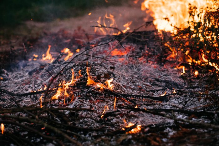
At the end of June, an out-of-control blaze took off in the steep and rocky terrain of British Columbia’s Fraser Canyon, just south of the village of Lytton. Eventually, the fire destroyed an estimated 90% of Lytton including the post office and the health centre and caused 2 fatalities. In the middle of July, another major fire started between Kamloops and Vernon along Highway 97, known as the White Rock Lake fire. This fire spread through the community of Monte Lake – the second British Columbia community destroyed by fire this summer – and was only brought under control in mid-September. Insurance losses from both major fires totalled $164 million. In addition to the human losses and property, fires killed millions of wild animals and destroyed wildlife habitats, and generated smoke that was carried both to the South Coast and east across the Rockies. Often in the path of forest fires this summer, Kamloops experienced a record 478 hours of smoke and haze. In the southeastern corner of the province, Castlegar also had a record 295 hours of smoke.
On July 10, fires were out-of-control in every province and territory except for Atlantic Canada and Nunavut. Alberta was a noticeable exception. Whereas the number of fires was close to normal in Alberta, the area burned was surprisingly only 15 percent of normal. Little of the smoke affecting Albertans came from homegrown fires. Air-quality alerts became a daily fact-of-life across the West as air-cleansing rains and upper winds were absent for much of the summer. At times, the sun-blocking haze reduced afternoon temperatures by 5 °C or more. In Prairie big sky country, skies were often eerie-grey-orange and you couldn’t see across the street. Calgary recorded 512 hours of smoke and haze (normal yearly count is 12 hours) – the dirtiest skies in 70 years of record keeping. At the Calgary Stampede, horseracing and chuckwagon races were cancelled over safety concerns for animals, participants and spectators. Edmonton was less affected with 125 hours this year, but that was still the second smokiest summer since 1953 and 9 times the normal number of smoke hours.
Another hot spot for burned woodland extended eastward from Saskatchewan to northwestern Ontario where the percentage of area burned was between 2 and 8 times the 10-year average. In Saskatchewan in May, the fast-moving Cloverdale Fire ignited between La Ronge and Prince Albert before jumping highways, burning down transmission lines and cutting power to 9000 customers. Prince Albert declared a local state of emergency. La Ronge suffered through 293 hours of smoke and haze in 2021. Regina recorded 147 smoke hours compared to just 5 hours in 2020 – the most the city has seen since 1995 and the third-highest number in nearly 70 years. Thick billowing smoke from wildfires east of Berens River, Manitoba and from northwestern Ontario left the air thick with the smell of burning timber. More than 1300 people from Manitoba First Nations communities were evacuated. In Winnipeg, hours of smoke totalled 239, the second most since 1953 and 16 times the normal.
In Northwestern Ontario, hot and dry weather in spring and summer contributed to prime fire conditions. There were 50% more forest fires compared to the 10-year average, but they burned 5 times the average area burned in a year. The Province of Ontario called it the worst forest fire season on record, surpassing the previous record in 1995 by 10%. The largest-ever fire on record occurred near Kenora, burning out of control for nearly 5 months. Ontario imposed restrictions on mining, rail, construction and transportation activities in order to reduce the likelihood of sparks igniting more fires. More than 3000 evacuees from Ontario First Nations communities were relocated to the south with an added 5000 people on short-notice alert.
5. Canada rides out four heatwaves
Across Canada, summer 2021 ranked as the fifth warmest season in the past 74 years. Only Nunavut had temperatures closer to normal. In the far west, British Columbia, Alberta and Saskatchewan experienced their warmest summers in at least 60 years, where heat warnings prevailed across entire provinces. Although the British Columbia heatwave was certainly the most impactful heat event of the year, the frequency of extreme heat all over the country was a significant part of all Canadians’ weather experience in 2021. As a mark of how scorching and consistently hot it was, days with temperatures of 30 °C or greater occurred for 5 months. In Edmonton, hot days numbered more than all such days for the previous 8 years combined. In Winnipeg, no year has ever had more days above 30 °C (35 in 2021, compared to a normal of 13). In Saskatoon, July 2 topped 40 °C. While summer went missing in the East in July, the heat came roaring back during the second and third weeks of August. Montreal recorded its warmest August on record with records dating back to 1871. Several cities also experienced very warm nights – part of a long-term trend seen across North America and Europe over the past several decades. For instance, Toronto had 14 nights with temperatures above 20 °C compared to an average of 4 such nights. Worst in the East was the oppressive and sultry humidity. At times the air in the East was not only hot and humid but also loaded with ash and smoke from wildfires in northwestern Ontario and Manitoba.
Whereas Canada was consistently warm from May to August, the heat came in waves, with at least 4 bouts of 40-30-20 days: humidex values near 40 or above, hot afternoons exceeding 30 °C, and tropical nights above 20 °C.
First heat wave
Around the May long weekend, maximum temperatures from Ontario to Newfoundland and Labrador rose to the high 20s and even above 30 °C. However, at the end of May, the early heatwave ended sharply with record below-freezing temperatures. The West’s first heatwave came at the beginning of June, about a month earlier than normal, when 70 new record-high temperatures occurred. That was before the apocalyptic heat dome that scorched much of Western Canada at the end of June. In the precursor event, heat temperatures exceeded 35 °C in some Alberta and Saskatchewan towns and touched 40 °C in Manitoba, surpassing century-old records by as much as 4 or 5 degrees. Public health officials invoked early health measures to counter the heat extremes. It was a good test for what was to follow 3 weeks later.
Second heatwave
About a week after the first heatwave in the East, torrid heat enveloped the region again from June 4 to June 9 with several sites reporting temperatures exceeding 30 °C for 3 to 5 consecutive days, some at 14 degrees warmer than normal. Humidity was even more spectacular with humidex values exceeding 40. The hot and humid weather also brought deteriorating air quality and high-risk air quality health values. The heat triggered an early surge in electricity demand as residents cranked up the air conditioning and fans.
In Western Canada during the last week of June, the sizzling heatwave left little unsinged. Thousands of temperature records were shattered, including a Canadian record of 49.6 °C at Lytton, British Columbia. At the end of June, more than 80 per cent of the Prairies were under a lethal heat warning with a week or more of temperatures ranging between 30 °C and 50 °C. In Calgary, it was the second-hottest June on record, with the hottest day, June 29, coming in at 36.3 °C, only 0.2 °C off the highest temperature ever recorded in the city. In Vancouver, temperatures at the end of June soared above 30 °C for 4 days and set a new all-time record of 32.4 °C on June 29. Normally, the city experiences a +30 °C temperature once every 3 or 4 years.
Third heat wave
Just days after the fatal heat dome shrunk, a third heat wave gripped the West. Again, scorching temperatures prevailed across the Prairies ranging from 30 to 35 °C during the 2 middle weeks of July. The heat was compounded by a prolonged drought. In the East, nature took a break during July. But during the second week of August, Ontario, Quebec and the Maritimes saw record high temperatures to the mid-30s, made worse by humidex values of 40 to 45. The third wave saw some of the warmest nights of the entire summer. For example, in Toronto, there were 5 overnight lows above 20 °C including August 10 that had a low of 23.4 °C at 3 a.m. and a corresponding humidex of 34.
Fourth heatwave
The summer’s fourth and final wave was coast-to-coast in scope and the nation’s most enduring heat spell lasting for 2 to 3 weeks. It began in the West during the final week of July and persisted to mid-August, typically the dog days of summer. By mid-August, heat warnings were in effect in 9 provinces. In British Columbia and Alberta, the multi-day heat was made worse by the struggle to contain wildfires and smoke. In the British Columbia Interior, some places topped 40 °C again, 10 ° warmer than seasonal values. The heat was too much for Okanagan’s horticulture harvest. Apples still on trees were sunburned or baked. Alberta came under either heat warnings or smoke advisories or both. In Edmonton, the average June to mid-August temperature registered the second warmest period on record only below that in 1961. In early August, high-temperature records were smashed in at least 6 communities in the Northwest Territories, including Yellowknife’s 32.6 °C on August 2, eclipsing the previous record of 32.5 °C, set on July 16, 1989.
In the East, there were only a couple of days between heat waves 3 and 4. With the third wave persisting from August 9 to 13 and the fourth from August 17 to 26, giving the impression of a hot spell lasting 15 to 20 days. In Montreal, because of the nearly 2-week long heat spell, August turned out to be the hottest in 145 years. The city did break the record set in 1916 for the number of days at 33 °C or more. Newfoundland and Labrador was not left out in the cold. On August 16, temperatures began reaching and exceeding 30 °C across Newfoundland and into southeastern Labrador.
6. Year of the EF2 tornado
Tornadoes with a rating of 2 or greater on the Enhanced Fujita scale (EF2) account for about 8% of all of the tornadoes that have struck Canada, with none of that rating occurring in some years. With wind speeds between 180 and 220 km/h, EF2s are strong enough to tear off roofs from well-built houses, push frame homes off foundations, snap or uproot 50% of trees along the storm’s track, lift cars off the ground and propel objects a few kilometres away.
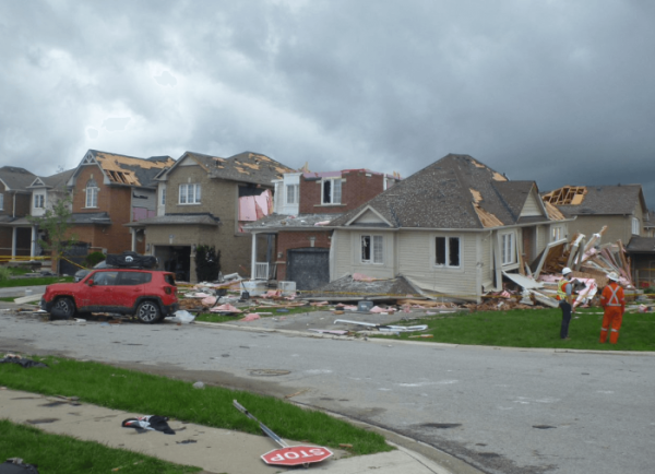
Quebec’s most significant EF2 tornado occurred in the afternoon of June 21 when warm humid air and an associated cold front generated multiple tornadoes between 3 p.m. and 5 p.m. The first tornado struck St-Valentin at 3:35 pm. Ten minutes later the day’s strongest tornado hit a residential area east of Mascouche. The EF2-rated tornado lasted 15 to 20 seconds over a 6.5 km track and sideswiped the community with winds of 180 to 200 km/h. The tornado was both fatal and destructive. It took the life of a man who had sought refuge in a shed – the first tornado victim in Québec in 27 years. The municipality reported 75 to 100 homes had suffered major damage, from upper floors ripped away, to structures pushed off their foundation. Roof shingles, vinyl siding, tree parts and pieces of bicycles, lawnmowers and barbecues littered the ground for over 3 kilometres.
Weather forecasters in Ontario expected July 15 to be a busy and stormy day. Thunderstorms first appeared around noon and at 2:30 p.m., the first EF2 tornado touched down west of Highway 400 and moved through a southeast neighbourhood of Barrie. Eyewitnesses to the weather that day confirmed that nature gave little warning of impending severe conditions. There was no prior rain nor angry skies. The sky was without lightning and thunder, there were no strong foretelling winds and certainly no dark ominous clouds with frightening green patches. The Barrie tornado was confirmed as a high-end EF2 with maximum winds of 210 km/h along a damage track of 12.5 km long and 510 m wide. In total, 150 homes were damaged with nearly half deemed uninhabitable. Several dwellings had second stories taken clear off. Nearly 700 vehicles were damaged, with a few lifted and rolled. Scores of fences were ripped up and a trampoline was launched and set down in someone else’s yard. Broken glass and balls of insulation coated the scene for 3 kilometres. Preliminary property insurance losses were at over $100 million. Fortunately, though, there were no deaths or critical injuries. As it turned out the Barrie tornado was not the day’s only EF2. Surprisingly, 6 other tornadoes were confirmed as EF2 and 3 as EF1, although none were as destructive as the Barrie storm.
7. Dreaded Arctic blast freezes Canada in February
Winter was remarkably mild across Canada until February when suddenly the dreaded Arctic blast from Siberia arrived over the heart of North America. At the same time, a high-pressure system over Greenland intensified drawing mild air up along the Atlantic coast. This circulation created dramatic temperature contrasts of 20 °C below normal in Alberta and Saskatchewan and 20 °C above normal in southern Baffin Island. A moderate-strength La Niña in the equatorial Pacific Ocean was partly responsible, but the extreme cold of February’s Arctic blast played a major role.
The centre of the Arctic blast settled on the Prairies for 2 weeks in February and wrapped its icy arms around all of Canada. Around Valentine’s Day weekend, every single square kilometre of the country from Victoria to St. John’s was frozen. The Prairies were under an extreme cold warning with afternoon highs of -34 °C and nighttime wind chills of -45 to -55. The extreme cold on the Prairies was said to be once in a lifetime cold and broke temperature records going back more than 50 years. During the second week of February, over 225 new daily low minimum temperature records were set across Western Canada and the Yukon with an equivalent number of low daily maximum records. Canada saw its coldest temperature in 4 years with -51.9 °C at Wekweètì, Northwest Territories. In Winnipeg, a new cold-weather record of -38.8 °C was set on February 13, colder than the peak on Mount Everest. From February 6 to February 14, the temperature in Winnipeg never got warmer than -22 °C. On February 7, Edmonton International Airport came within 0.1° of breaking an all-time daily record at -43.9 °C in 1994.
This extreme and enduring cold had adverse impacts on both individuals and communities. In some Prairie cities, neighbourhood agencies opened additional beds to shelter more people. Free overnight bus service was also provided to get people out of the cold. The extreme cold broke countless water mains and cracked urban rail lines. Energy utilities set many new daily records for natural gas consumption and the cold drove the demand for propane to the highest in decades. The bone-chilling cold was even too chilly for skiing and snowboarding. In Calgary, the cold weather delayed Chinook Blast, a new winter festival meant to celebrate Calgary’s famous warm winds. In Edmonton, at the world’s Longest Hockey Game minimum temperatures dipped to -42°C. Pucks hitting a goal post shattered into pieces.
The fact that it had not been a tough winter until February made the cold spell feel much colder. Prior to February’s Arctic blast, the average afternoon temperature in Winnipeg between November and January was the warmest on record, with observations dating back to the 1870s. In addition, February’s cold snap had minimal effect on the winter temperature as a whole. For North America, the average temperature from December 2020 to February 2021 inclusive still placed this winter as the 11th warmest of the past century.
8. Another hailer-flooder in Calgary
For the second year in a row, and for 9 of the last 12 years, Calgary hailstorms are making it to the year’s list of significant Canadian weather events. The city has a well-known reputation as the hailstorm capital of Canada. Calgary’s high altitude to the lee of the Rockies in a favoured area for storm development increases the chances of big hailers occurring each year. Last year, the number one weather story was a 20-minute hailer – a billion-dollar buster – the country’s most expensive hailstorm and the fourth most expensive storm in Canadian history. On July 2, 2021, near-perfect atmospheric conditions prevailed allowing a major thunderstorm cell to pop up along the foothills and sweep eastward across the city. An early morning thunderstorm and a heat warning led to a stormy day. The day’s maximum temperature exceeded 30 °C. The day before had been much hotter with a high of 36.3 °C (the city’s second-highest temperature in 150 years).
On the wild Friday afternoon, a series of weather warnings and watches signalled the arrival of 5 hours of thunderstorms. The stormy results were 50 mm of rain, moderate-strength winds, and copious amounts of hailstones ranging in size from dimes to golf balls. More threatening were rotating funnel clouds and multiple lightning strikes. The storm led to localized flooding, turning roads into rivers and underpasses into canals. Emergency Services responded to 200 calls in 2 hours including rescues of stranded motorists when waters rose to vehicle door handles.
Basement sewer backups were also reported. The hail dimpled vehicles and riddled house siding with millions of dents. While there were nearly 16 000 insurance claims for damages to vehicles from cracked or smashed windshields and dented hulls totalling $128 million; total storm losses from 39 000 insurance claims exceeded $555 million.
9. Hurricane Larry belonged to Newfoundland
Following a record active hurricane season in 2020 with 30 tropical storms across the Atlantic basin, this year continued to be busy with 21 named tropical storms from Ana to Wanda, and 7 hurricanes, of which 4 were major or intense at sustained winds of 178 km/h or greater. Based on cyclone energy, tropical storms were stronger and longer, lasting about 50% above the long-term average.
From July 9 to 10, tropical storm Elsa brought 50 to 100 mm of torrential rains and strong winds to parts of the Maritimes during its post-tropical phase. Apart from hydroelectric losses to 26 000 homes and businesses, the region escaped relatively unscathed. Tropical storm Henri made landfall in New England on August 22 before tracking south of the Maritimes as a post-tropical depression a few days later, but no major impacts were reported in Canada. Major Hurricane Ida was one of the most powerful hurricanes ever to strike the United States Gulf Coast, making landfall in Louisiana on August 29. But it was the remnants of Ida that brought 150 to 200 mm of rain to a large swath of the American Northeast from Philadelphia to Boston and record rains and enormous floods to New York City. Ida’s remnants also tracked through the Maritimes on September 1 and 2 and into Newfoundland and Labrador the next day. In comparison with the United States, Ida was more manageable in Canada with soaking rains and wind gusts clocked at 70 to 110 km/h. In the 3 Maritime Provinces, 25 stations recorded in excess of 100 mm with half those stations in Prince Edward Island including Summerside and Charlottetown. Several stations broke new single-day rainfall records. With rainfall rates at more than 30 mm or more per hour and strong winds, several roadways and parking lots became overwhelmed. Streets in Charlottetown became impassable when vehicles were submerged up to the door handles. Following Ida’s deluge, much of the province’s shellfish sector (mussels and clams) closed for a week or longer due to the risk of contaminates from excess runoff.
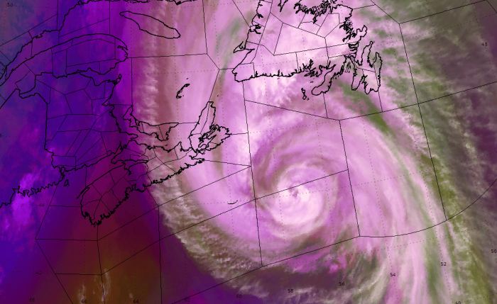
Almost immediately upon developing off West Africa on August 31, Hurricane Larry grew into a large and powerful storm. It made history as the longest-living major hurricane in the Atlantic basin, with sustained winds above 175 km/h for almost an entire week from September 3 until September 8. On September 9, Larry passed 305 km east of Bermuda before accelerating towards Newfoundland and Labrador. Larry entered Canadian waters on September 10 as a Category 2 hurricane with sustained winds of 155 km/h. The hurricane packed a lot of force with the usual strong winds and heavy rains along with causing large swells, dangerous surf, damaging breaking waves and rip currents. Until September 11, Larry was a so-called “fish storm” staying out over the ocean and posing no threat to ship or land.
Larry was no Igor at least from a total rainfall perspective, but Newfoundland and Labrador took a nasty blow from the wind and storm surge. Rains were hurricane-standard – heavy and intense, yet brief. Around midnight NDT on September 11, Larry made landfall as a Category 1 storm just west of the Avalon Peninsula with sustained winds of 130 km/h and wind gusts up to 180 km/h. Larry transitioned into a post-tropical storm while traversing the province. Winds caused widespread power outages from toppled trees and broken branches, one school lost its roof and in St. John’s a huge performance tent was destroyed. More than 60 000 customers lost power during the storm. In addition, there were widespread damages to coastal infrastructure. The storm surge combined with high tides to wreak havoc on some coastal communities in eastern parts of the province where several routes were eroded and closed for days. Several parks lost precious trees and were closed. Recalling the impacts from Igor in 2010, residents rushed out days following Labour Day to stock up on supplies to last several days. Damages would have been more extensive but weather-warned residents took pre-storm advisories seriously by tying down outdoor furniture and trimming trees, while work crews cleared culverts and catch basins and readied barricades. Clean up went on for days following Larry’s exit into the North Atlantic. Early-estimated property losses from the insurance sector exceeded $25 million with 2200 claims.
On September 19, moisture from post-tropical storm Odette contributed heavy rains from thunderstorms across Eastern Nova Scotia, especially over Cape Breton Island. Ingonish Beach and Eskasoni were among the wettest places with 55 to 65 mm of rain with over half of the total falling in 1 hour. St. John’s had 50 mm of rain, which was made worse by Larry’s lesser rains a week before. Hurricane Sam pretty well left Newfoundland alone on the last days of September staying out to sea as it passed by Eastern Canada.
10. January prairie clipper
In the second week of January, the tail end of an atmospheric river system from the Pacific Ocean energized into an intense Alberta Clipper that raced across the western Prairies. The system brought strengthening downslope winds in excess of 100 km/h to much of southern and central Alberta and southern Saskatchewan following several days of impactful weather. There were 76 wind-measuring stations that captured gusts exceeding 100 km/h, including 13 with all-time January records, such as 137 km/h winds at Barnwell, Alberta and 143 km/h at Bratt’s Lake, Saskatchewan. At the Moose Jaw Airport, winds reached 161 km/h. During the storm, so many anemometers blew away that undoubtedly many more records were set than were reported.
The rain, freezing rain and lightning ahead of the system quickly changed to snow and blowing snow as the storm advanced eastward. The freezing rain led to slick polished surfaces and widespread power outages across the west. Blizzard conditions created zero visibility across the Prairies that led to several highway closures and saw people trapped in their cars for several hours. The fierce winds led to widespread structural losses. In southern Alberta, winds tipped over semi-trucks spreading debris across highways. Rooftop HVAC equipment went missing as did garbage bins. Saskatchewan bore the brunt of the storm’s fury, seeing the most prolonged period of extreme wind gusts. In Regina, the indoor, elevated pedestrian walkway across major downtown arteries was damaged in places. Across rural districts, the storm smashed sheds and barns, bent irrigation equipment, and crumpled grain bins. Power outages were widespread, affecting cellular and internet services. Over 100 communities reported outages affecting more than 100 000 customers, some for 4 days. Before the storm left British Columbia, power losses had affected 212 000 customers in the lower mainland and southern Vancouver Island. This storm, and a wind squall a week later, resulted in total property insurance claims across the 4 western provinces approaching $155 million, with the majority of the losses in Saskatchewan.
Regional weather highlights and runner-up events in 2021
Atlantic Canada
- First winter storm not until the New Year
- Weather bomb revs up snowblowers
- Groundhog Day storm 2021
- Storm debilitates Atlantic Canada for a week or more
- Winter’s one day of misery for Moncton
- Lion-like March storm slams Atlantic Canada
- Rare March lightning
- Easter rain and ice storm with loss at sea
- Newfoundland’s record April showers
- Rare Nova Scotia tornadoes
- Thin, weak ice off and on Labrador affects life
- Where are the icebergs?
- Atlantic Canada’s atmospheric river
Quebec
- Groundhog Day storm slows traffic
- Early March blizzard closes highways
- Lightning storm wakes up Montrealers
- Winter-Spring storm slams the East
- Record minimum ice conditions in the Gulf
- Winter’s last hurrah
- Pollen explosion
- Trois-Rivières thunderstorm
- August sweltering and sultry in Quebec
- October storms and two final tornadoes
Ontario
- Winter wallop shuts learning at home and school
- Lion-like storm
- Mid-March wind storm across Ontario
- Winter-Spring storm slams Ontario and beyond
- Ontario’s April snowfall
- Pollen explosion
- Chatsworth tornado
- Soaker in southwestern Ontario
- Jet winds across Ontario
- Never-ending rainstorm across Ontario
- Ontario’s record October mildness
- Northwestern Ontario’s first snows are a doozy
Prairie Provinces
- Alberta wind squall
- Late March Prairie blows
- Pleas for rain finally answered on May long weekend
- Winds damage Manitoba property in early June
- Return to winter in June following May heatwave
- Altona tornado
- Bring the rain, forget the wind
- Rare multi-tornado day
- First tornado in weeks
- Rescue rains – too little too late
- August ends with a weather bang
- Time to let the cows out of the barn
- Sensational September across the Eastern Prairies
- Summer comes back in October
- Remembrance Day storm to remember
British Columbia
- BC’s first winter storms
- Cold and record snows just days before Valentines
- March windstorm leads to power outages
- Flooding in the midst of coming drought
- September rains, rains and more rains
- Pacific weather bombs – among the most powerful ever
- Rare Vancouver tornado
The North
- Record January mildness
- Whitehorse’s record snowy winter – a possible flood threat
- Another year of retreating and thinning sea ice
- Following record cold comes record warm in Yukon
- Winter snows = Summer floods
- Heat advisories in the North
- Weather rarity
- October in the North – more rubber boots than winter boots
David Phillips has been the Senior Climatologist for Environment and Climate Change Canada for 30 years and employed with the Meteorological Service of Canada for nearly 55 years. His work activities relate to the study of the climate of Canada and to promote awareness and understanding of meteorology. He is best known as the originator and author of the Canadian Weather Trivia Calendar for 31 years. He frequently appears on national and local media as a commentator on weather and climate matters. David is a fellow of both CMOS (1999) and the Royal Canadian Geographic Society (1993). He has written Canada’s top ten weather events each year for 26 years beginning with the Saguenay Flood in 1996.
Canadian weather, David Phillips, extreme weather, top ten weather stories