
Seasonal Outlook for the Spring 2018 (MAM) based on the official CanSIPS forecast issued on the 28th Feb. 2018
– By M. Markovic, B. Merryfield and K. Gauthier, CMC, Montreal –
Spring forecast (March, April, May) for 2018 temperature and precipitation in Canada includes above normal temperatures across eastern Canada, and equal chances for below/near/above normal precipitation across most of Canada.
Spring Forecast is for Above normal temperatures most likely in eastern Canada and eastern Canadian Prairies
The highest probabilities (>60%) for a warm spring are in the Maritimes, ON, QC and in the northern Canada, whereas in southern QC and ON this probability is 50-60%. Chances are ~equal for a cool, normal or warm spring over the AB, YK and western NT, and near normal values are most likely in central and coastal BC.
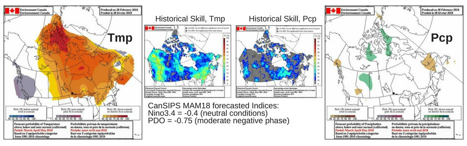
Equal chances for below/near/above normal precipitation across most of Canada
There is a probability of >40% for above normal precipitation over scattered regions of AB and northern Canada, and >40% for below normal precipitation over northeastern Canada. Otherwise, equal probability chances are expected across Canada for the spring.
What will influence the next season?
There are currently weak La Niña conditions in the central equatorial Pacific that are forecast to dissipate and have little impact over Canada in spring. ECCC predicts neutral ENSO conditions (-0.5 to +0.5 °C) to persist throughout this spring and summer. According to the ENSO forecast issued by International Research Institute (IRI), there is a probability of ~70% that neutral conditions will remain this spring. PDO index is expected to remain negative in MAM18, moderately influencing coastal BC regions. Negative NAO index (according to the NOAA/CPC prediction) is forecasted at least until mid-March after which the forecasting skill is low. Negative NAO is historically linked with above average temperatures across eastern Canada. PNA index will likely stay negative (until mid March, according to the CPC). Negative PNA index is historically linked to below normal spring temperatures particularly for western Canada.
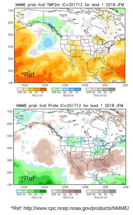
Seasonal forecast by other centers:
Temperature (figure on right, top): There is a significant difference between CanSIPS and the longer lead forecast from NMME (upper figure) in all Canadian regions. NMME is forecasting equal chances for temperature probability in the northern, central and eastern Canada. According to the NMME there is slightly elevated probability for below normal temperatures over the west coast. Over the Great Lakes region both systems agree on forecasted probabilities of >40% for above normal.
Precipitation (figure on right, bottom): Like CanSIPS, the longer lead forecast from NMME (lower figure) predicts equal chances for below/near/above normal across most Canadian regions. However differences are seen in the locations where these probabilities are elevated to >40%.
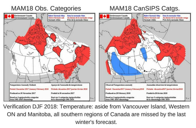
Bill Merryfield, CanSIPS, Kevin Gauthier, Marko Markovic, Spring Forecast