
Tornadoes on the Canadian Prairies: 1826-1939 — Part 2, Project Results
-By Patrick McCarthy and Jay Anderson-
Abstract
Kendrew and Currie (1955) commented on prairie tornadoes in their 1955 publication The Climate of Central Canada: “…they probably occur in Alberta and Manitoba but there is no definite evidence,” while noting that Saskatchewan averaged only about one per year. After an exhaustive effort, we have compiled the most complete historical database of Canadian prairie tornadoes before 1940. This included a total of 589 rated tornadoes, with 152 having a damage track. The project also yielded a more complete account of tornado deaths and injured for the period.
Results
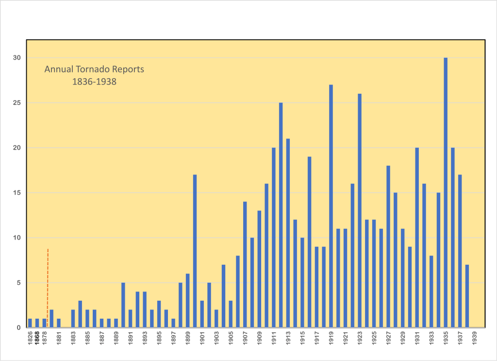
Most early events occurred in the more-populated eastern prairies. Beginning in the 1880s, agricultural farms and communities grew along the railway lines that were being laid westward across the plains. By 1900, there began a significant increase in tornado reports in Saskatchewan and Alberta (Figure 1).
The 1826-1939 tornado occurrences are mostly south of the tree line, spread across the prairie region (Figure 2). Tornado reports often trace out those railway lines. This artifact is due to tornado reports being associated with a nearby town, village, or rail station, even though the tornado may have been quite distant. These are well-known distributions to Environment Canada’s forecasters, though highways have replaced railways as the alignment axis. The broad climatological characteristics of Prairie tornadoes were evident from a very early stage.
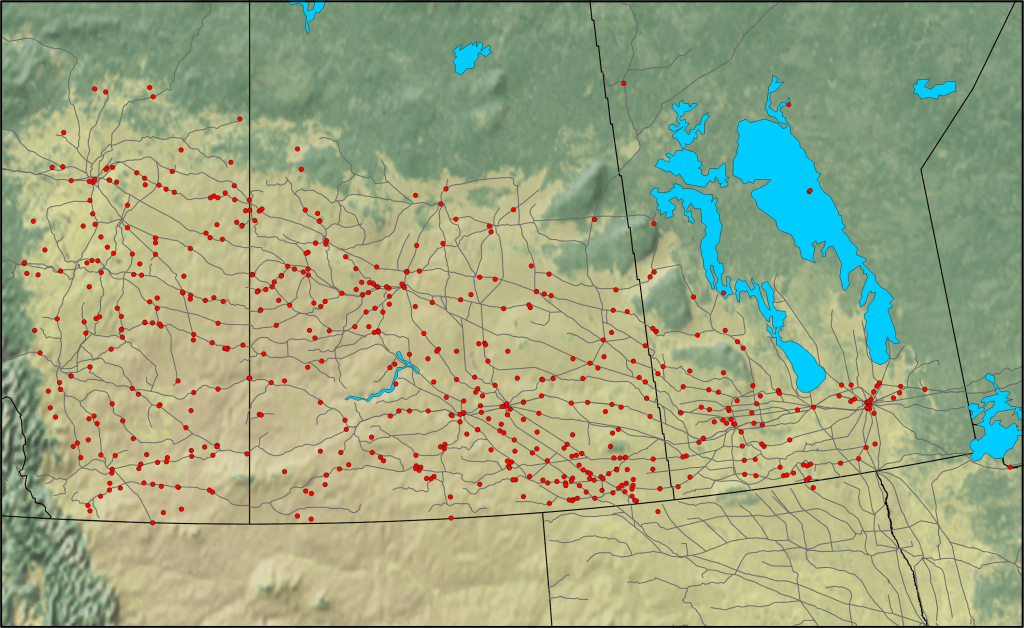
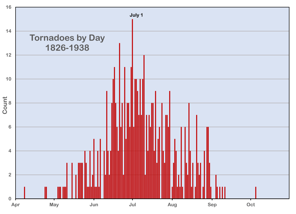
Figure 3 shows that the largest number of tornadoes occurred from mid-June to mid-July. Observations of late evening and overnight tornadoes are limited by darkness, a bias that we attempted to overcome by examination of the synoptic situation and the reported damage tracks. The northern latitude of the region means that civil twilight ends at 10:30 pm and begins at 4:30 am in late June leaving only a six-hour period of darkness at the height of summer. This period for observable tornadoes is among the longest in North America.
It is the nature of the Prairie tornado that there are significant stochastic variations in reported events from year to year, ranging from zero to 30 in our sample. This may or may not represent differences in climatological conditions in individual years, as we cannot know how complete our sample is. It is only recently, with the popularity of storm chasing, cell phone cameras, and social media that annual tornado counts have begun to reflect the actual frequency of events closely enough to derive a useful climatology. Recently, the Northern Tornadoes Project (2020) has demonstrated that intensive damage surveying can reveal a more complete account of tornadoes and their tracks.
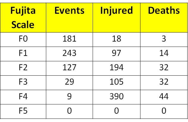
We estimated the strength of tornadoes according to a hybrid Fujita – Enhanced Fujita Scale, as described in our Part 1 article. The ability to come up with a definitive value is limited when information is sparse. Table 1 shows the distribution of our F-value estimates. The deficiency in F0 values is most likely due to their weak and transient nature, which makes them less likely to be observed, reported, or newsworthy. The data also suggests that deaths and injuries are more likely with stronger tornadoes.
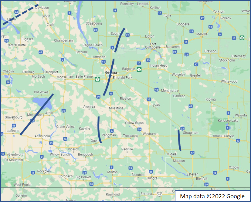
Most early tornado reports contained only a single observation. Typically, only the more severe events included comments about the path location and length. Individual reports also tended to be limited by reference to a single nearby community. We endeavoured to be more precise by finding additional eyewitness accounts of each event that would allow a track to be established and by triangulating reports to obtain a more accurate position. From this improved dataset, we were able to estimate the tracks of 152 tornadoes in the pre-1940 era. In the case of the 1912 Regina tornado (Figure 4), we were able to find seven tornado tracks in the outbreak that day—a result that is comparable to the 1987 Edmonton tornado event.
One consequence of the research was the uncovering of additional events for inclusion into the severe weather database, including elements such as deaths due to lightning, major hail events, and unusual phenomena such as raining frogs and fish falling from the sky. In a few exceptional cases, a detailed assessment of extreme non-tornadic wind events, such as the 1922 Manitoba derecho, was constructed. These mesoscale convective systems often have embedded and difficult-to-detect tornadic circulations.
Ongoing work
As online digital databases continue to grow, we will likely see further adjustments to this early dataset. Moving forward, we are now examining the period from 1940 to 1979. The current database for this time frame contains over 900 possible tornado events. The goal is to have a comprehensive, reliable, accurate, and public dataset of tornadoes from the first reports on the Canadian Prairies to the present.
References
Kendrew, Wilfrid George, and Balfour W. Currie, 1955. The climate of central Canada– Manitoba, Saskatchewan, Alberta and the Districts of Mackenzie and Keewatin. E. Cloutier, Queen’s Printer, Ottawa, 152.
Sills, D. M. L., Kopp, G. A., Elliott, L., Jaffe, A. L., Sutherland, L., Miller, C. S., Kunkel, J. M., Hong, E., Stevenson, S. A., & Wang, W. (2020). The Northern Tornadoes Project: Uncovering Canada’s True Tornado Climatology, Bulletin of the American Meteorological Society, 101(12), E2113-E2132. Retrieved Oct 7, 2022, from https://journals.ametsoc.org/view/journals/bams/101/12/BAMS-D-20-0012.1.xml
Patrick McCarthy is a retired Meteorological Service of Canada meteorologist and former Head of the Prairie and Arctic Storm Prediction Centre. He is an active weather history buff, storm chaser, and the Chair of the CMOS Winnipeg Centre.
Jay Anderson is a meteorologist, formerly with Environment Canada, where he worked primarily in Winnipeg and Vancouver over a 34-year career. Since his retirement, he has been working casually as a consultant, primarily in the travel industry, and teaching storm chasing at the University of Manitoba