
Toward Quantifying Area-fugitive Greenhouse Gas (GHG) Emissions from Open-pit Mines
– By Amir Nazem, Md. Rafsan Nahian, Ryan Byerlay, Manoj K. Nambiar, and Amir A. Aliabadi-
Conventional techniques to quantify area-fugitive Greenhouse Gas (GHG) emissions from an open-pit mine have serious drawbacks. The bottom-up approach is based on inventory estimates, in which the emissions from different stationary sources across a mining facility are combined. This approach does not include the atmospheric measurements of GHGs or meteorology and relies on assumptions of the strength of each GHG source within a facility that may not be up-to-date.
The top-down approach, however, makes use of an aircraft to directly measure the atmospheric meteorological conditions and mixing ratios of GHGs. The downsides of this methodology are high cost as well as limitations of flying around a facility all-year-round, at nights, and at low altitudes. Other techniques such as Inverse Dispersion Modelling (IDM) also suffer in lack of accuracy because they assume horizontal homogeneity in meteorological conditions, a condition that is seldom met for complex topographies (Liggio, 2016) (Gordon, 2015).
Objective:
A new methodology incorporates high resolution numerical modelling to forecast the fluxes of GHG emissions as a function of time and space given accurate initial and boundary conditions for meteorology and GHG mixing ratios near the source. This article summarizes the first step toward this goal, which is meteorological predictions over a complex open-pit mine. Details of adaptation of a numerical weather model with topographical and land use changes over an open-pit mining facility are discussed. Also, brief results are provided revealing near-surface meteorological processes.
Methodology:
Open pit mining activity creates a significant land surface modification through changes in surface elevation and land use in the scale of tens of kilometers. These modifications affect the local meteorology by affecting the near-surface wind field, and temperature. Such processes are investigated using a distribution of the Weather Research and Forecasting (WRF) model titled the Unified Environmental Modelling System (UEMS).
The weather model builds the computational atmospheric domains on top of a static land surface domain (including topography and land use). The static domain parameters are retrieved from the global datasets. Often the terrestrial data are not updated with the latest land use or topographical changes made to a fast-pace industrial site (e.g. a rapidly changing open-pit mine). Studying the local meteorology over such modified regions based on old terrestrial data is highly questionable. In addition, the local meteorology is highly dependent on local microscale phenomena, while the default global datasets are provided at relatively low resolution.
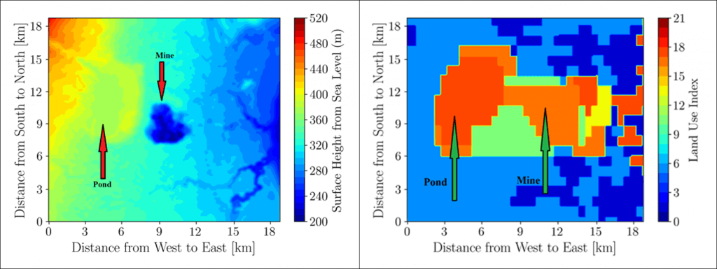
A procedure to acquire and incorporate high resolution static information including topography and land use changes and incorporating them into the global terrestrial data was needed and was implemented to ensure accurate simulation of meteorology for a rapidly-changing open-pit mine environment in northern Canada for May 2018. The default topography of the site was the Global 30 Arc-second (GTOPO 30s) dataset, but it was modified using the Shuttle Radar Topography Mission 1 Arc-Second (SRTM 1s) dataset and a local LIDAR dataset with a resolution of 1m. The default land use dataset was the MODerate Resolution Imaging Spectroradiometer (MODIS) 30s 20-category IGBP data product but, it was modified using a MODIS 30s 21-category IGBP data product observing the recent land use changes at the site and incorporating a lake model (Friedl et al. 2010, Subin et al. 2012 and Gu et al. 2015 ). Fig. 1 shows the modifications of topography and land use for the open-pit mining facility.
Results:
To visualize the sensitivity of the model results to the change in topography and land use, contours of near-surface wind velocity magnitude and direction are plotted in Fig. 2 for both the default topography and the case with high resolution topography and land use updated. The results demonstrate a notable difference in flow patterns because of changing topography and land use classification. Particularly, lower wind speeds and a local circulation is are predicted inside the mine-pit during night time (thermally stable condition). On the other hand, lower wind speeds and meandering of wind direction are predicted over the tailings pond during day time (thermally unstable condition).
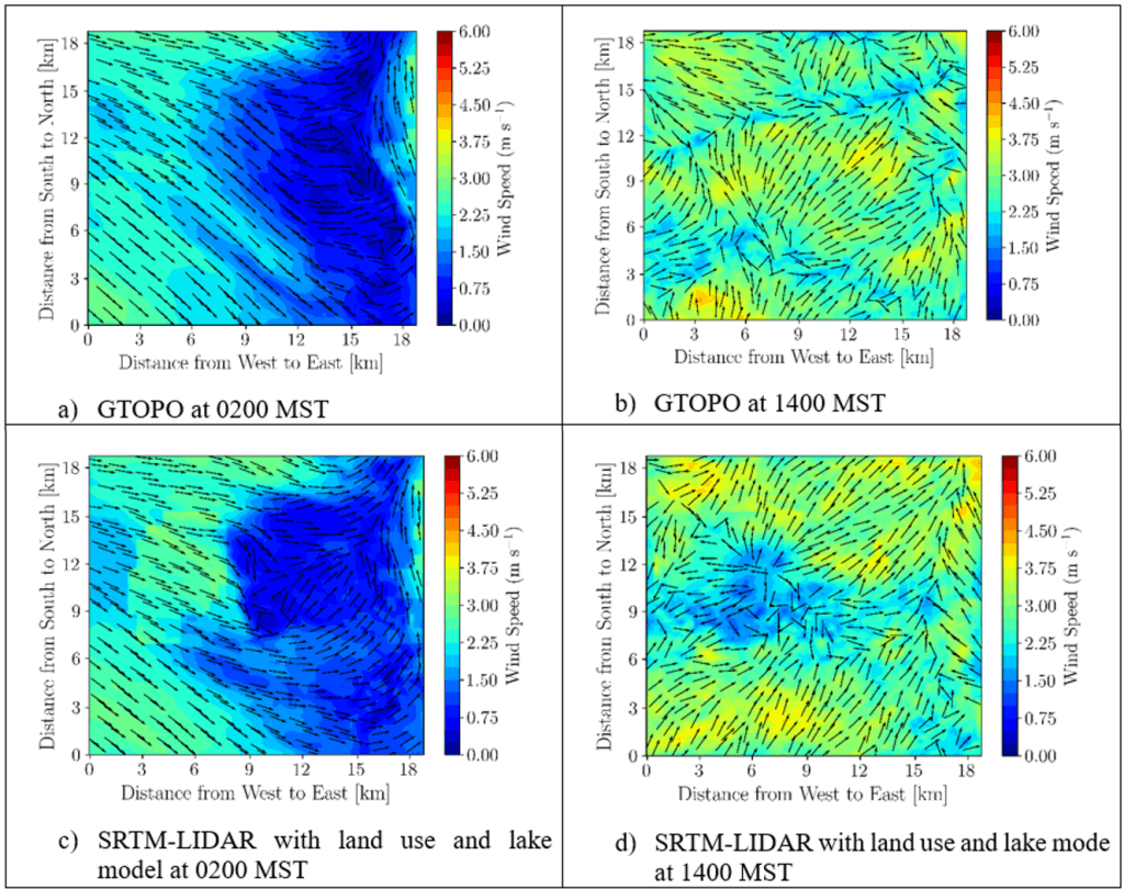
Fig. 3 shows the contours of near-surface potential temperature corresponding to the thermally stable and unstable atmospheres. The contours show that the model’s predictions in both the thermally stable and unstable atmospheres are sensitive to the changes in topography and land use. Adding a body of water (tailings pond) tends to reduce the near-surface potential temperature compared to the surroundings during daytime, while it tends to increase the near-surface potential temperature compared to the surroundings during nighttime.
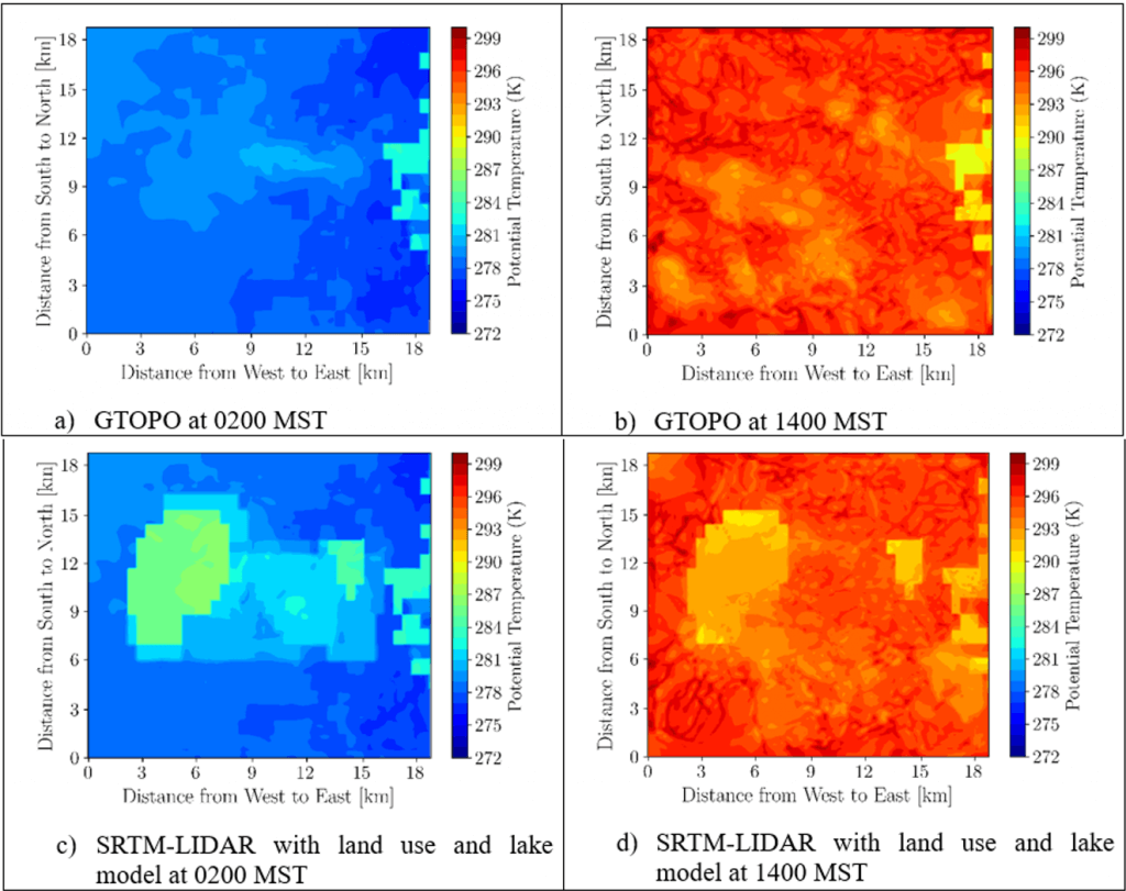
These phenomena are likely due to the difference between heat capacity of water and surrounding land surfaces as well as the modified aerodynamic roughness of the land surface due to the presence of the mine pit.
Conclusion:
This study demonstrates the effectiveness of the Weather Research Forecasting (WRF) model in predicting the meteorological conditions over an open-pit mine under fair weather conditions in northern Canada. The recent changes in the topography and land use of the mine indicates notable changes in meteorological conditions as predicted by WRF. This is the first step toward quantifying area-fugitive Greenhouse Gas (GHG) emissions, while future effort requires detailed plume dispersion and flux integration of GHGs inserted in the WRF model as boundary conditions.
High-resolution meteorological modelling shows promise toward more accurate quantification of area-fugitive GHG emission fluxes from open-pit mining facilities. This technique overcomes the current limitations of operational approaches such as bottom-up, top-down, and Inverse Dispersion Modelling (IDM) methods of quantifying area-fugitive GHG emissions.
About the Author

Amir is an air quality meteorologist working with the ministry of environment, BC. He did his Master’s of Applied Science in Environmental Engineering at the University of Guelph. During his Master’s program, Amir had the opportunity to participate in an important project to develop a new methodology to estimate the emissions of greenhouse gases from an open pit mining facility in Northern Canada. They incorporate both the experimental and numerical fluid mechanics and coupled the micro and meso scales to forecast the pollution independent of time and space, which is the topic of this article.
email: Amir.Nazem@wsp.com
Note:
A full version of this study is under review in the Journal of Applied Meteorology and Climatology.
More Like This:
Amir Nazem, Fugitive greenhouse gas emissions, Meteorological modelling, Open-pit mining, Weather Research Forecasting