
Searching towards creating a sustainable integrated mesonet for the Canadian Prairie Provinces
– By Jeannine-Marie St-Jacques1, Aston Chipanshi2, Trevor Hadwen2, Allan Friesen1, and David Sauchyn3 –
Due to the continental nature of the Canadian Prairie Provinces, their weather and climate are characterized by extremes. With this reality, the Prairie Provinces should benefit from high resolution weather monitoring from an integrated weather mesonet. A mesonet consists of any number of automated weather stations with an average spacing of 1 to 50 kilometers. This station spacing is much denser than that of the Environment and Climate Change Canada weather stations and can therefore capture local weather conditions in a much more detailed fashion. There have been efforts by Agriculture and Agri-Food Canada (AAFC) to use all the available weather data from the Canadian Prairie Provinces to form an integrated mesonet from federal, provincial and private weather networks. Due to large weather station gaps across Canada, the National Agroclimate Information Service (NAIS) has made special arrangements with various weather providers, including private ones, over the years to use their data to produce occasional value-added weather products for Canada’s agricultural regions. However, there has been little momentum to legally formalize data sharing agreements to create a permanent integrated mesonet that can guarantee a continuous, regular availability of weather data to various stakeholders. Our study’s ultimate goal is to show the potential benefits of including multiple weather networks in a Prairie Provinces integrated mesonet to improve data coverage, since any one network may not be enough to support the sensitive economic sectors found here. We propose that such a comprehensive mesonet can provide more detailed weather information at finer space and time scales and reduce the cost of data collection and distribution for any one governmental agency.
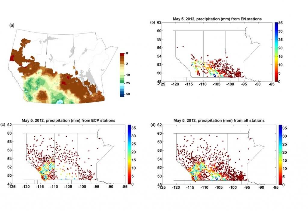
We met this goal by assessing how temperature and precipitation are captured temporally and spatially on the Canadian Prairies by the weather stations of a private provider network, Earth Networks (EN), relative to stations operated by federal and provincial governments. Specifically, we examined how weather events during the 2012 growing season were captured by the high-resolution, non-World Meteorological Organization (WMO) standard EN network, relative to the WMO standard weather stations operated by federal and provincial governments. In particular, we tested how storm events from the study area were captured by each weather network. We found that there was a large amount of missing EN data. There was a significant pattern of the EN stations having higher hourly temperature values later in the day and higher daily minimum temperatures than their nearest neighboring governmental stations did. There also was a significant pattern of the EN stations having less daily and hourly precipitation than their nearest neighboring governmental stations did. This is possibly due to the non-WMO siting of some of the EN stations. However, overall, the EN stations and the various governmental stations were complimentary, often with one network being denser where the other one was sparse and vice-versa; thereby giving a more spatially detailed picture of five storms of the 2012 growing season (Fig. 1). Hence, we show the benefits of including this high-resolution EN weather data, together with government station data, in a permanent, formally established integrated mesonet for the Canadian Prairies, with a much higher spatial and temporal resolution than the individual contributing networks.
LINK TO THE FULL ARTICLE RECENTLY PUBLISHED IN ATMOSPHERE-OCEAN
About the Author

Dr. Jeannine-Marie St-Jacques has been an assistant professor in the Geography, Planning and Environment Department of Concordia University in Montreal, Quebec, since 2013. Prior to this, she spent nine years at the Prairie Adaptation Research Collaborative at the University of Regina, Saskatchewan as a post-doctoral fellow and research associate. Her research interests are climatology, hydrology, paleoclimatology, paleo-environmental reconstructions, tree-ring studies and climate modelling.
*Author Affiliations: 1Geography, Planning and Environment, Concordia University, Montréal, Québec2Agricultural and Agri-Food Canada, Regina, Saskatchewan3Prairie Adaptation Research Collaborative, University of Regina, Regina, Saskatchewan
More Like This:
Canadian Prairies, Concorida University, Jeannine-Marie St-Jacques, Mesonet, weather data