
Seasonal Outlook for the winter 2019/2020 (DJF) based on the official CanSIPS forecast issued on the 30th Nov. 2019
– By M. Markovic, B. Merryfield, M. Alarie, Environment and Climate Change Canada –
Seasonal Outlook for winter 2019/20 (December, January, February) in Canada is for elevated temperatures in southern and eastern Canada and above normal precipitation for much of the country.
Seasonal Outlook, Temperature
Elevated probabilities for warmer than normal are expected across southern and eastern Canada. The highest probabilities for such a forecast are expected over the Great Lakes region (>70%), southern and Central Ontario (>60%), southern QC(>60%) and the Maritimes (50-60%). Central Canadian prairies and southern BC are expecting weaker probability for above normal winter of 40-50%.
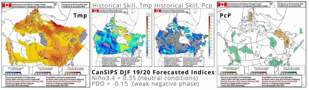
Seasonal Outlook, Precipitation
Modest chance of above normal precipitation over the southernmost Ontario and BC? There is a 40-50% probability for this outcome in southern and central continental BC. Above normal precip. is also most likely over northern AB, MB and northwestern QC (>40%). Below normal precipitation is likely at 40-50% over Labrador and eastern parts of the Maritimes. White areas on the map mean equal chances are expected for precipitation this winter.
Seasonal forecast by other centers
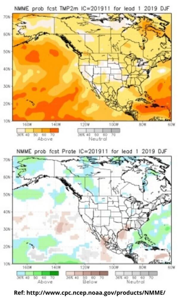
Temperature: There is a good agreement between NMME (longer lead forecast) and CanSIPS seasonal forecasts. According to the NMME (North American Multi Model Ensemble) (lead 1 month), probability of above normal temperatures (>40%) is expected over the entire North American continent. Regions with the highest probabilities are southern British Colombia and northern Quebec (>50%). The two systems also agree on the equal chance possibilities over northern Alberta.
Precipitation: There is an agreement between CanSIPS and a longer lead forecast from NMME (lower figure), over the BC and AB where NMME is forecasting this precipitation zone more to the east. There is also agreement over north- western QC where both systems forecast probabilities of 40% or more. Difference between the two systems is seen over the NFLD, Maritimes and over the Great Lakes region. NMME is forecasting equal precip. chances over these three regions.
What will influence the next season?
It is highly likely that a neutral ENSO will occur in the equatorial Pacific this winter. ECCC predicts this neutral condition to persist into the following spring. According to the longer lead seasonal forecast issued by International Research Institute (IRI), there is a probability of ~60% that a neutral ENSO will prevail this winter and of ~70% to continue in spring. PDO index is expected to remain weak this winter, with a very limited influence to the coastal areas. PNA index will remain positive for the first part of December after which the skill is low. Historically, positive PNA is related to below normal temperatures over NE Canada. Besides neutral ENSO conditions, currently there are no major low frequency anomalies that may influence Canadian winter. Positive SST anomalies observed in the north Pacific ocean, off the coast of BC, are likely caused by the atmospheric ridging in the region and can potentially bring some warm air in the coastal region as a consequence of downstream advection.
More Like This:
Environment and Climate Change Canada, Marko Markovic, seasonal outlook, winter forecast